Has Noah’s Ark Finally Been Found? Scientists Use Below Ground Electrical Signals to Create 3D Image-But is it Noah’s Ark?
By Ken Griffith July 2020
(Note, this article was transferred from a prior website and the photos referenced are at the bottom of this article)
The mysterious Mr. Parker has asked me to evaluate some of the recent Noah's Ark claims coming from explorers in Turkey and Iraq. However, I am not a disinterested party. I was in Turkey in November 2019 looking at yet another ark site, when a researcher made another announcement to the press that he found Noah's Ark at the Durupinar Site.
Let's talk about the other ark sites, and then I will tell you where I think it is or was located.
The most explored ark site has been Mount Ararat, a 16,800 foot glacier-capped mountain on the border of Turkey and Armenia. Over the past century dozens of explorers have undertaken missions to find the ark there using planes, helicopters, and hiking on foot.
Most recently a Hong Kong religious group called NAMI claimed to be led by a Kurdish guide into a cave inside a glacier on the top with a barn-like structure inside. However, it turned out that most of the footage was supplied by their guide, and was not actually taken by them on the summit.
While one other explorer has returned to the site since then, NAMI has yet to publish a paper with their findings. Many creationists believe NAMI was deceived by a fraud, or was party to a fraud on the public.
I cannot speak to that, but I can evaluate the general claims that Mount Ararat was the landing site for the Ark.
One obvious problem with Mount Ararat as the landing site is that it is nearly 17,000 feet high. At this elevation some of the animals and the people would have had difficulty surviving without supplemental oxygen. The temperature at the top never rises above freezing.
Yes, the mountain is currently named Ararat, and the Bible says the ark came to rest "in the mountains of RRT". RRT has been translated as Ararat or Urartu, which was an ancient kingdom in the mountains of North Mesopotamia.
For reasons I will explain below, the current Mount Ararat is almost certainly not the place called by that name when Genesis was composed or edited by Ezra the Scribe in the time of Nebuchadnezzar. In the 1960's a nurse-anesthesiologist from Tennessee named Ron Wyatt explored a site called Durupinar about 60 miles Southeast of Mount Ararat. The Durupinar site is the location of a mudflow that encountered a hard rock outcrop in its path and flowed around it.
The mud later hardened into rock leaving a roughly boat shaped formation about the length of Noah's Ark. Since then other explorers have visited the site, and Turkey even built a visitors center, renaming the nearby hilltop as Kudi Dag.
The Koran says Noah's Ark came to rest on mount Cudi, or Judi.
There are at least six Mount Cudis spread between Turkey, Iraq, and Iran. This suggests that the Muslims forgot or perhaps never knew precisely where the Ark site was. The most famous one is on the border of Turkey and Iraq just north of Mosul, called Mount Judi. Anne Habermehl, a creationist researcher, writer, and speaker, has been the main champion of Mount Judi as the correct landing site. Her case is based mostly on history and tradition, which I think is a good angle from which to approach the question.
However, many of her arguments apply equally well to the site that I would like to tell you about.
Other sites for Cudi Dag are said to be in the Sinjar Mountains of Iraq, and near Lake Urmia in Iran. Explorers of several of these sites have claimed to find fossilized wood up there, proving there was an ark on the mountain top.
Here are the reasons I reject Mount Ararat, Durupina, and Mount Judi as the landing site of the Ark.
1. The Durupinar site looks vaguely like a boat. However, the ark was a chest, not a boat. It was not powered by sails, oars, or propellers. Therefore it did not require the v shaped hull and hydrodynamic design. A v-shaped hull is more likely to roll in the waves, which is why ship captains must point their vessels into the wind during a storm. It is more likely that the Ark was shaped roughly like a box or a coffin with rounded corners.
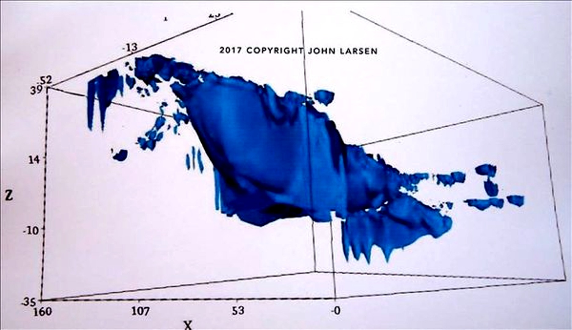
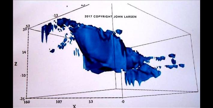
2. The Hebrew word for "ark" means "chest". The fact that ground penetrating radar shows the rock formation is roughly the shape of a boat hull does not prove it is the Ark. It merely proves that the mudflow around the outcropping created a three dimensional shape roughly matching a boat hull.
3. There are two similar boat shaped formations about 30 kilometers Northwest of the Durupinar site. Perhaps these are the fossilized remains of the Nina, the Pinta, and the Santa Maria?
4. Other than a boat shaped rock formation what other evidence is there for the Durupinar site actually being a fossilized ark?
5. The Durupinar, Iraq, and Iran sites where explorers claimed to find fossilized wood all raise the question - how can wood become fossilized without being buried in silicate rich soil with a high flow of anoxic groundwater? If we dropped a wooden vessel on a mountain top at sub-glacial elevation what would we expect to happen to it? It would rot. What if it was made of special rot-resistant wood? It would take a lot longer to rot, but rot it still would. This problem applies to any site in which fossilized wood is claimed to be remains of the ark. If the ark was buried in ice, what would happen? It would be crushed and torn to pieces.
6. Ararat, Durupinar, and Mount Cudi are all due North of Babylon by hundreds of miles. The description of Babel relative to the Ark given in Genesis 10-11 is on an East-West axis. Based on other traditions such as Jubilees, Babel was near the Ark, not hundreds of miles away. This makes sense.
If you got dropped on a mountain top in a cargo ship in a new world with no roads, how far would you be willing to carry your tools and belongings on foot to found your new capital city in the new world?
Approach to Finding the Ark Site
I took a different approach to look for the site of the ark and the related Tower of Babel. I took a broad survey of the scriptural description, as well as history, biology, and archaeology to find evidence of where the ark and tower of babel might be. Are these two historical sites related?
Absolutely, they are connected to one another in the Scriptural narrative. Genesis 9 tells us that after Noah disembarked from the ark, he built an altar and then became a farmer. These two activities probably happened in close proximity.
According to Josephus, Noah's family were priests at the entrance to the Garden of Eden prior to the Flood. There must have been an altar not far from the gate where they ministered as priests on behalf of mankind.
The altar on which Noah sacrificed and then God made the covenant of the rainbow would have been the holiest site on Earth until the Law was given to Moses about eight centuries later. The book of Jubilees tells us that Noah's tomb is near the ark and the altar on the mountain top.
This suggests the mountain was one on which people could live and was accessible. It is likely that given Noah's history as a priest at the entrance to Eden, he probably continued to be a priest at the altar of the rainbow covenant after the Flood.
He probably trained a line of his sons to continue that priesthood. This priesthood would have been the "Order of Melchizedek" mentioned in the book of Hebrews. Since Jesus Christ is a priest of the Order of Melchizedek, and since Jerusalem was destroyed, one might argue that the rainbow altar is one of the world's holiest sites even today.
Genesis 10 and 11 relate a story to us in which the fourth and fifth generation descendants of Noah rebelled against God's command to spread out into nations all over the Earth.
It says "they were moving about in the East" and then they built the city and tower of Babel. Some translations say from the east, others say to the east. The literal Hebrew says "moving about in the East." The Book of Jubilees also say they went East from the ark site to build Babel.
The phrase "in the East" is relative to some frame of reference. The only frame of reference we have is the ark landing site and altar described in Genesis 9. The statement that "God came down to see what they were doing" is typically interpreted as meaning that God came down from heaven. But it could also mean that God came down from the altar on the mountain top to see the city in the valley below.
The two sites that I have located fit this description. The ark and altar site is on a mountain about 30 miles West of the Babel site; and the Babel site is about 4,000 feet lower in elevation than the altar. Let me tell you how I found these sites.
There were three things that led me to these sites, and which convince me this is the right place for both the Ark and the Tower of Babel.
Clues from History
There are two clues to the location of Babel from history. One is from the Bible, and the other from an ancient king named Sargon. Reading in Genesis 10 we are told that Nimrod's first four cities were Babel, Erech, Accad, and Calnah. Then he left that land and went into Assyria and built Nineveh, Rehoboth Ir, Calah, and Resen.
Of those eight cities, we definitely know the location of Nineveh and Calah in Assyria. And, the order in which they are listed is going down-river, not upriver. If Babel was in lower Mesopotamia as nearly all scholars have assumed, then when Nimrod left that land, he would have had to go up the Tigris River. Why would the cities have been listed in reverse order?
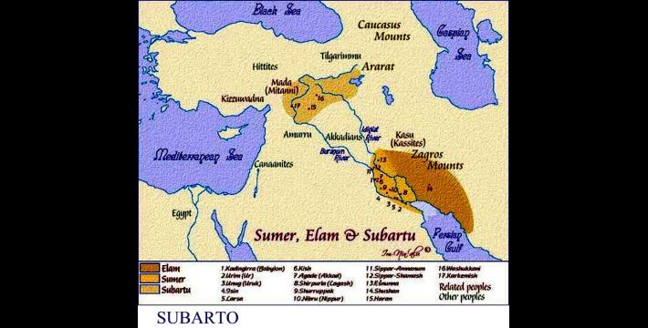
This, along with some arguments made by Anne Habermehl, caused me to consider whether Nimrod went down the Tigris River from Babel to Assyria. So, I started looking for sites upstream of Nineveh on the Tigris. Sargon of Akkad was one of the first empire building kings of lower Mesopotamia. He was king of a city called Agade or Akkad, similar to Nimrod's third city name. Sargon conquered a land to the North called "Subartu" and boasted that after he defeated them, he took their flocks, and herds, and possessions, and additionally, "I dug clay from the pit of Babylon, and I built a new Babylon opposite Akkad."
We have three versions of this story from various tablets dug up in Mesopotamia.
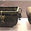
The place called "Subartu" by Sargon is known to be a valley on the upper Tigris River, where the Tigris and Euphrates come closest together. The question is what was the "pit of Babylon" that Sargon talked about? See Photo 2
We are told by Scripture and other sources that at Babel they made bricks "and baked them thoroughly" in order to build the city and the tower of Babel. This was unusual, because most ancient cities and villages were made of unfired adobe bricks. These cities melted into mounds when they were abandoned because adobe falls apart when it gets wet.
To make fired bricks requires soil with a higher clay content than is needed to make adobe. The context of Sargon's exploit is that he dug clay from the clay pit of the original Babel, and he used it to make some bricks and dedicated a new city of Babylon across the Euphrates River from his home city of Akkad in lower Mesopotamia, near Bagdad today.
About four centuries later, an Assyrian queen called Semiramis (II) is said to have turned the shrine at Babylon into a walled city. And shortly after that we see the first king of the First Dynasty of Babylon in the Babylonian King List.
This suggests that the Babylon where Nebuchadnezzar took the Jews into captivity in 606 BC was a different city than the original Tower of Babel. It was New Babylon, kind of like New York was later built and named after the city of York in Britain.
There is one more historical argument, but it is more about where Ararat is not. The Armenian name for Mt. Ararat is "Masis".
The Sumerians called the mountain where the Ark landed "Mashu." The Armenians today did not always live within the current borders of the country of Armenia. In past times Armenia was large country that encompassed the mountains of upper Mesopotamia from the border of modern Syria to Lake Van. When the Ottoman Turks invaded the region, they drove the Christian Armenians northward into their current location.
In the original homeland of Armenia, which is the same valley called Subartu by Sargon of Akkad, there is a mountain whose name was Masis or Masia. There is an iris endemic to this mountain named Masia.
The historical evidence suggests that when the Armenians were driven north, they took their place names with them, and renamed a new mountain "Masis" as well as some of the village and city names of their old territory. This is the main reason that the explorers of Mount Ararat are barking up the wrong tree.
Archaeological Evidence
If we want to find the Tower of Babel we should simply look for the oldest human villages and towns. Most scholars assume that Sumeria in lower Iraq had the world's oldest cities. The creationist professor, Dr. Petrovich argues that Babel was the city of Uruk because the Uruk Period saw colonies sent out from Uruk taking their culture all over the Middle East, and even to Egypt. However, Uruk is not the oldest city in the world.
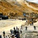
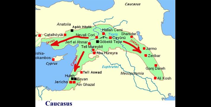
The oldest permanent human settlements are found in a culture that archaeologists call the "Pre-pottery Neolithic A". Neolithic means "new stone age". There are dozens of settlements that have been found in upper mesopotamia that are older than anything in lower mesopotamia.
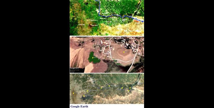
The map below (see Photo) shows where they are found. They did not use pottery because they used stone jars instead. Where did they get stone jars, you ask? Well, you might expect that if Noah put a year's worth of food in the Ark, he had to put it in containers. After the Flood was over, there was presumably a ship full of empty containers sitting on that mountain top. Why make new pots when you can get high quality stone jars from before the Flood for free?
If we look at a map of the Pre-pottery Neolithic A we immediately notice two things. First the shape is three prongs that seem to be going out from a center area. Two of the prongs of settlement going out seem to match Genesis 10's description of Canaan and Javan.
The third group whose territory is described in Genesis 10 was Joktan who went "from Mesha to Sephar, the great mountain of the East." We see the third prong of the PPNA follows the Zagros Mountains to the southeast into Iran. Thus the PPNA map seems to match Genesis 10. Second, if we look at the center of mass of the PPNA map below, we find a village and province name "Çınar", pronounced "chee-nar" about 15 kilometers south of the city of Diyarbakir, Turkey, on the upper Tigris River. This is the same valley called "Subartu" by Sargon the Great.
See Photo
Biological Evidence
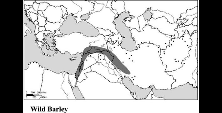
The neolithic revolution was the beginning of farming, at least in the post-Flood era. These founder crops were einkorn wheat, emmer wheat, barley, lentil, two kinds of pea, chickpea, and flax.
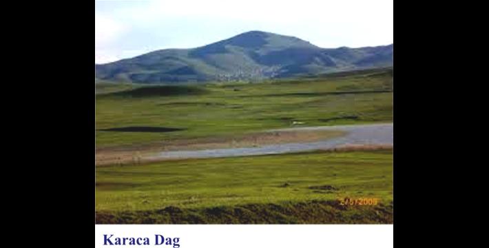
These plants still grow wild in the region of the PPNA. But looking at the their distribution, all of them are centered on the mountain just to the west of Çınar. That mountain is today called Karaca Dag. This is the same mountain that was originally called Mount Masis, or Mashu.
Map of Wild Barley Distribution - Karaca Dag is at the center top of the arc. See Photo
Mount Mashu
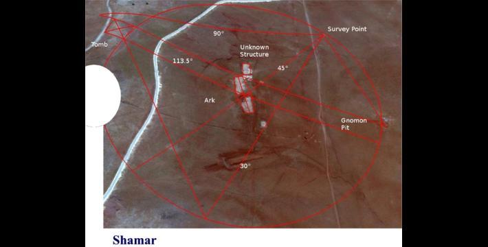
On top of Karaca Dag are many ancient sites and strange structures that appear to be tumuli or kurgan tombs. But one in particular is special. It appears to be a rough pyramid, 60 meters square, oriented to the Winter Solstice sunrise at 113.5 degrees on the horizon. This structure is located on the seventh peak of Karaca Dag counting from South to North.
Karaca Dag - the Original Mount Masis or Mashu
In the Epic of Gilgamesh we are told that Gilgamesh had to cross seven mountains to find Huwawa who lived in a house made of cedar on a mountain that was sacred to the Anunaki gods, and called the Land of the Living, and Mount Mashu. Huwawa surrendered, but Gilgamesh killed him anyway.
The word Huwawa appears to be a form of Yahweh or Jehovah. Gilgamesh went to the sacred mountain where the ark landed, and probably killed a priest of Jehovah at the altar next to the "house of cedar" which was the Ark. Then he went home to Uruk and claimed that he had killed Jehovah.
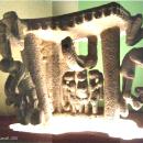
The mountain Karaca Dag fits the description of a mountain with eight peaks. The tomb and site that I believe are the landing site are at the seventh peak, as described by Gilgamesh. The tomb is next to a radar station built on the hilltop, and the probable ark site is below. However, it has been complicated by the fact that a modern school was built on the site around 1930, whose rubble covers the site today.
Finding Shinar
In order to find the Tower of Babel we need to find a site that meets these criteria:
* East of the ark site
* in the region of Subartu
* on a plain
* called Shinar
* on the upper Tigris River
* near the headwaters of both Tigris and Euphrates
* nearby source of a "terrible wind" that knocked the tower down according to Book of Jubilees.
* near three more cities of Nimrod
If we look 30 miles to the East of my proposed Ark site, we find a location that meets all of these criteria. In the image map, it is "Babel Site C" because it is the third of three candidate sites we looked at in November 2019. Of the four tels along the Tigris River from West to East, we know the name of the second one was Erech, as the name was preserved as Khurk. Only the first mound of the four has a claypit next to it. We believe that this never-excavated site will probably turn out to be the city and tower of Babel.
Conclusions
So now taking all the data together, we find that we have two sites for the Ark landing and Babel which are 30 miles apart, and fit the Scriptural description. They are also at the center of the Pre-pottery Neolithic A, and the center of the neolithic grain crops first used for farming. Additionally, the ark site appears to have a tomb and possibly an altar. (Though the radar base built on the hilltop may be where the altar was.)
These two sites are both within Mesopotamia, because they are between the Tigris and Euphrates Rivers, at their nearest point in Turkey.
Unlike the other proposed sites for the Ark, Karaca Dag fits all the data. The mountain top is only 6,300 feet, and there is evidence at the south end that farming was done there. It is not the most glorious ark site. The elevation and latitude are about the same as the Smoky Mountains of Tennessee. The ark itself is long rotted and gone. But the tomb remains. And perhaps if excavated properly, the tomb will prove that this is the correct site.
Ken Griffith is an amateur historian, adventurer, and explorer.

Please Support the Research of S8int.com!
Support S8int.com with a PayPal Donation!
More Posts About Featured